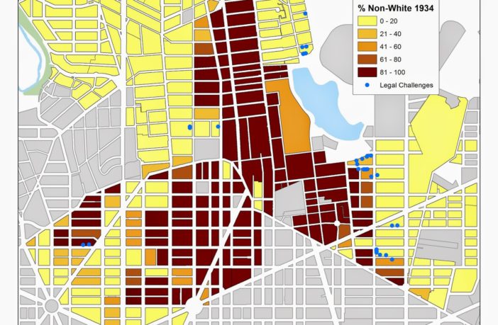
There’s an interesting event happening on Thursday at the MLK Library downtown and Sunday at the Mt. Pleasant Library: a talk from historians and researchers on the history of residential segregation in DC, focusing on Columbia Heights, Park View, Mt. Pleasant and other areas.
I’ve touched on this before, but back in the mid-20th century, realtors and city officials conspired to keep neighborhoods racially segregated: some where totally white while others were totally black. The term, called red-lining, was sadly widespread and the subject of many legal challenges, where black residents were not allowed to buy houses outside of certain areas.
In our area, parts of Columbia Heights and Park View were redlined, even with separate neighborhood groups (civic associations or community associations) for white residents and black residents — which is also why there is some confusion for neighborhood boundaries.
It’s an interesting topic, and will be presented by three people, including Brian Kraft, who leads the Columbia Heights Historic Drinkabouts, a walking tour with stops at local bars — highly recommended.
Here’s the full press release from the Library’s website
Please join us for Mapping Segregation in Washington, DC: Focusing on historic housing segregation in the Northwest DC neighborhoods of Bloomingdale, Columbia Heights, Mount Pleasant, Park View, and Pleasant Plains.
Mapping Segregation in Washington D.C. is a public history project whose goal is to create a set of layered, online maps illustrating the historic segregation of D.C.’s housing, schools, recreational facilities, and other public venues.
The first year has been focused on racially restrictive housing covenants mostly east of Rock Creek Park, and the legal challenges to them.
Come learn why many of D.C.’s “historically black” neighborhoods were once exclusively white, and how more recent shifts in the city’s racial identity have been shaped by this history.
Come see for yourself the maps we’ve created to show restricted neighborhoods, the legal battle lines, and who lived where over the years. Maps tell stories that words cannot.
Mapping Segregation in Washington D.C. is a collaboration among historians Mara Cherkasky and Sarah Shoenfeld of Prologue DC, historian/GIS specialist Brian Kraft of JMT Technology Group, and others. It is funded in part by the Humanities Council of Washington, DC.
Thursday, March 5 at 6:30 p.m.
MLK Memorial Library, Great Hall
901 G St. NW, Washington, DC 20001
Sunday, March 8 at 3:00 p.m.
Mt. Pleasant Neighborhood Library
3160 16th St. NW, Washington, DC 20010
Questions to mara@prologuedc.com or sarah@prologuedc.com.


