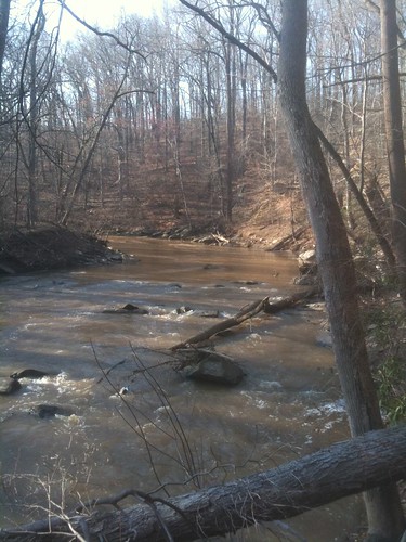
Last Sunday it was too nice to stay inside, so a friend and I decided to go hiking in Rock Creek Park. The park has a number of trails from Georgetown to Maryland, and a few of them are a short walk from the neighborhood. It was a lot of fun and a nice hike, and along the way we saw rapids, bridges covered in huge rocks, and even a Civil War fort.
The park is interesting because after a few minutes it’s much quieter and not at all like the city, but you still have cell phone service and can pick up a cab or go into a neighborhood with a 10-minute walk.
We went down Park Road into the park and attempted to pick up the Valley Trail heading north (here’s a map: to see it from their site, click “View Map” below the “Rock Creek Park” text on their website.) Unfortunately we got a little turned around and went up Piney Branch. Eventually we hit the trail, which goes from creek level to bluffs high above it. Our plan was to hike up to Military Road, check out Fort DeRussy, part of the Civil War defenses of Washington, and head back down the Western Ridge Trail on the other side of the park. That was a little too optimistic, as we were tired by the time we crossed the park on Military Road.
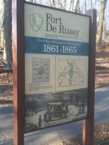 In all, we went about 6.5 miles in 3 hours, and it was good exercise. The fort itself is very interesting, it’s still quite large with earth parapets and big ditches around it. It was built to guard the valley of Rock Creek. Plaques there say the fort was able to fire cannonballs into Maryland. You may not know that there was a Civil War battle fought in DC, Battle of Fort Stevens at what is today Georgia Avenue and Quackenbos Street (where the Georgia Avenue Thrift Store is today). Fort DeRussy was involved in the battle, firing its cannons across Rock Creek to Fort Stevens, helping to defeat the Confederates.
After that, we walked towards Connecticut Avenue and caught a cab back home. It was the first hike I’ve taken that ended in a cab ride.
If you wanted to be more aggressive, you probably could go all the way to Maryland. In all, there were some strenuous parts, but nothing as tough as say Shenandoah National Park.
Have you gone hiking in Rock Creek Park? Any suggestions?
UPDATE: Here’s how to find the Valley Trail trailhead, from the Potomac Appalachian Trail Club:
The southern trailhead for Valley Trail is indeed difficult to find and is poorly signed.
In fact, I’m having signs made this spring and summer, and that end of Valley Trail will receive several of them.
Valley and Western Ridge Trails form an 11 mile loop and connect at Boundary Bridge (on the north end very near the MD/DC border) and Bluff Bridge (at the south end). There are signs on the west side of Bluff Bridge, but none that mark off where Valley Trail crosses Beach Drive and Park Road. As one walks north from Bluff Bridge on the east side of Rock Creek (on the sidewalk), look for blue blazes and a post off to the right. As I recall, they are a few hundred feet away. Turn right and walk across Beach and Park Roads. There are blue blazes marking the path. Once you cross Park Road, continue up the slope. That’s Valley Trail. Piney Branch Trail goes to the right. Valley Trail is marked by blue blazes, and they should be in good condition. So follow those. Thanks again for writing and enjoy yourself on the trails.


