 |
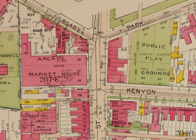
| 14th/Park/Kenyon in 1921. The Civic Plaza was a playground! |
Something I briefly mentioned in the post about Acre 121 was an old real estate atlas from 1909 — it’s by a surveyor named G. William Baist, and thus the books are called Baist books. There’s a series of them on the Library of Congress’s website that you can browse, from 1903, 1907, 1909/11, 1913/15, to 1921. They’re pretty amazing, and really show the growth of the neighborhood in those 18 years.
If you click on any of the title pages you can browse around each sheet, which shows a few block area — usually Columbia Heights is in book 2 or 3.
There’s definitely interesting stuff to be found — In the 1903 maps, the area is pretty empty and there are some wood houses (yellow) in what became Meridian Hill Park, while by 1921 there’s buildings everywhere and the park is an actual park. The maps also show the Arcade/Market House/Car Park building, which used to have a 14-lane bowling alley, pool, basketball courts and more. The Palace 5ive skate shop was named for a pro team that played there called Palace Five. Who knew we used to have a pro basketball team? The Heritage Trail talks more about the building too — check it out the trail if you haven’t already.
But there’s more: The 1903 maps have old street names, like Kenesaw for Irving and Yale for Fairmont, while by 1921 they’re the ones we’d recognize. The names of the old subdivisions are on there in big letters, like “John Sheaman’s Sub” for the area around 14th and Irving and “University Park” and the “Columbia College Lands” for the area to the south near University Place, which later moved to Foggy Bottom and became GW. The numbers on the houses are their lot numbers.
 |
| East of Meridian Hill, 1903. Click for bigger version. |
 |
| Same general area, 1921 |
Really though, don’t take my word for it, browse around and see what you find. Let us know in the comments!


